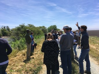
 Gathering on a levee on the San Joaquin River (to the left), with fields on the Nature Conservancy's Staten Island Farm to the right. Gathering on a levee on the San Joaquin River (to the left), with fields on the Nature Conservancy's Staten Island Farm to the right. The bus wound along the two lane road past a levee on a recent windy Friday. Looking out to the right, over the levee we saw the San Joaquin River, carrying water coursing out of the Sierra Nevadas towards the San Francisco Bay. On the left, a good 10-15 feet below the level of the river, fields sat ready for spring planting.
We were on a tour of agricultural extension work in San Joaquin County, sponsored by the University of California Global Food Initiative, where I am a Fellow. San Joaquin County, just outside the San Francisco Bay area, is part of California’s agricultural heartland. Rich organic soils on the west side in the Delta region transition to the California state soil, the San Joaquin sandy loam, on the eastern side closer the Sierras. Extension advisers and specialists in the University of California Agriculture and Natural Resources division help farmers in this highly productive region answer practical questions, like what cover crops to plant and when to mow them down, why some but not all of their grape vines are dying, and what cherry varieties to plant for good crop production in a warming climate. As we traveled through the Delta, I asked the specialist with us why the field soils were so much lower than the river. In other words, why were they subsiding? She noted the intensely productive nature of the delta soils, and replied that subsidence is a natural process that results from farming these rich soils. The farm advisor at our first tour stop, the Staten Island Natural Conservancy Farm, gave us a few more clues. He described how the Delta was a network of freshwater peat wetlands for several thousand years up until California’s Gold Rush in the 1850s. Before European contact, Yokut people hunted in the Delta and relied on the tule reeds for building materials. European settler colonialism decimated local indigenous peoples, with survivors relocated to Rancherias (the Spanish equivalent of reservations). Wetlands were drained to “reclaim land” during and after the Gold Rush, with levees constructed first out of peat (they didn’t last) and then out of sediments from gold mining that were clogging up the local rivers. The crux of the sinking land situation has to do with draining the wetlands. As the organic carbon in the peat is exposed to oxygen, soil microbes use it for fuel, voraciously transforming it to carbon dioxide. For a soil high in organic matter like peat, this means a large part of the soil is literally turning into air, with 50 pounds of carbon dioxide released daily from each acre of drained Delta wetlands, according to the USGS. The volume of soil shrinks, and, just like in the Netherlands, the level of the land surface drops. Reflooding the historic marshland reduces the loss of organic carbon to carbon dioxide, but eliminates agricultural land uses and can sometimes increase emissions of methane, another greenhouse gas even more potent than carbon dioxide. With the development of carbon markets, scientists are looking more closely into the benefits of reflooding Delta wetlands, and it’s possible farmers could get carbon credits for restoring their land to wetlands. However, waterfowl on the Pacific Flyway, like the cranes and geese at the Staten Island Farm, have become reliant on agricultural habitat and leftover grain to support overwintering populations. Like many problems in the agriculture+environment nexus, there is no easy answer to the question of how to protect subsiding Delta soils.
0 Comments
|
AuthorSarick Matzen completed his PhD in Environmental Science, Policy, and Management department at University of California, Berkeley in 2020. He is now a postdoc in the Soil, Water, and Climate Department at the University of Minnesota working on iron cycling in marine systems. Archives
July 2019
Categories |
 RSS Feed
